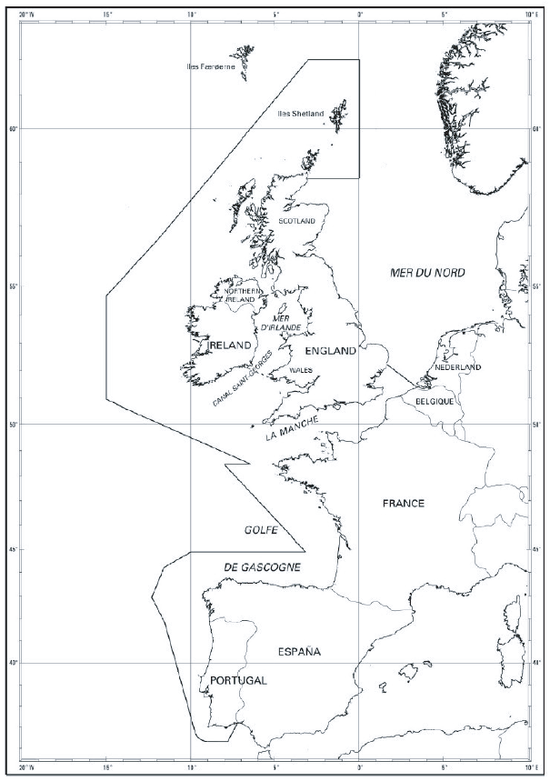
1.1 The area covers the Western coasts of the
United Kingdom, Ireland, Belgium, France, Spain and Portugal, from
the Shetland Islands in the North to Cape S. Vicente in the South,
and the English Channel and its approaches, as shown in the map below.
1.2 The PSSA is the area bounded by a line connecting
the following geographical co-ordinates (all the co-ordinates are
in WGS 84 reference system):
| Number
|
Latitude
|
Longitude
|
| 1 (UK)
|
58°30'N
|
UK coast
|
| 2 (UK)
|
58°30'N
|
000°W
|
| 3 (UK)
|
62°N
|
000°W
|
| 4 (UK)
|
62°N
|
003°W
|
| 5 (UK+ Irl)
|
56°30'N
|
012°W
|
| 6 (Irl)
|
54°40'40.9"N
|
015°W
|
| 7 (Irl)
|
50°56'45.3"N
|
015°W
|
| 8 (Irl+UK+F)
|
48°27'N
|
006°25'W
|
| 9 (F)
|
48°27'N
|
008°W
|
| 10 (F+S)
|
44°52'N
|
003°10'W
|
| 11 (S)
|
44°52'N
|
010°W
|
| 12 (S)
|
44°14'N
|
011°34'W
|
| 13 (S)
|
42°55'N
|
012°18'W
|
| 14 (S+P)
|
41°50'N
|
011°34'W
|
| 15(P)
|
37°00'N
|
009°49'W
|
| 16 (P)
|
36°20'N
|
009°00'W
|
| 17(P)
|
36°20'N
|
007°47'W
|
| 18 (P)
|
37°10'N
|
007°25'W
|
| 19 (B)
|
51°22'25"N
|
003°21'52.5"E
|
| 20 (UK)
|
52°12'N
|
UK east coast
|
| 21 (IRL)
|
52°10.3'N
|
006°21.8'W
|
| 22 (UK)
|
52°01.52'N
|
005°04.18'W
|
| 23 (UK)
|
54°51.43'N
|
005°08.47'W
|
| 24 (UK)
|
54°40.39'N
|
005°34.34'W
|
1.3 The geographical co-ordinates for the identification
of a PSSA are solely for that purpose and must not be interpreted
as having any bearing upon issues related with maritime limits and
boundaries.

PSSA Chart - Western European Waters Particularly Sensitive Sea Area